
Find a list of all our campuses and locations across Australia and beyond.
Transport news and updates
Our University is expanding its industrial research precinct to help the region develop the critical skills needed for the energy transition.
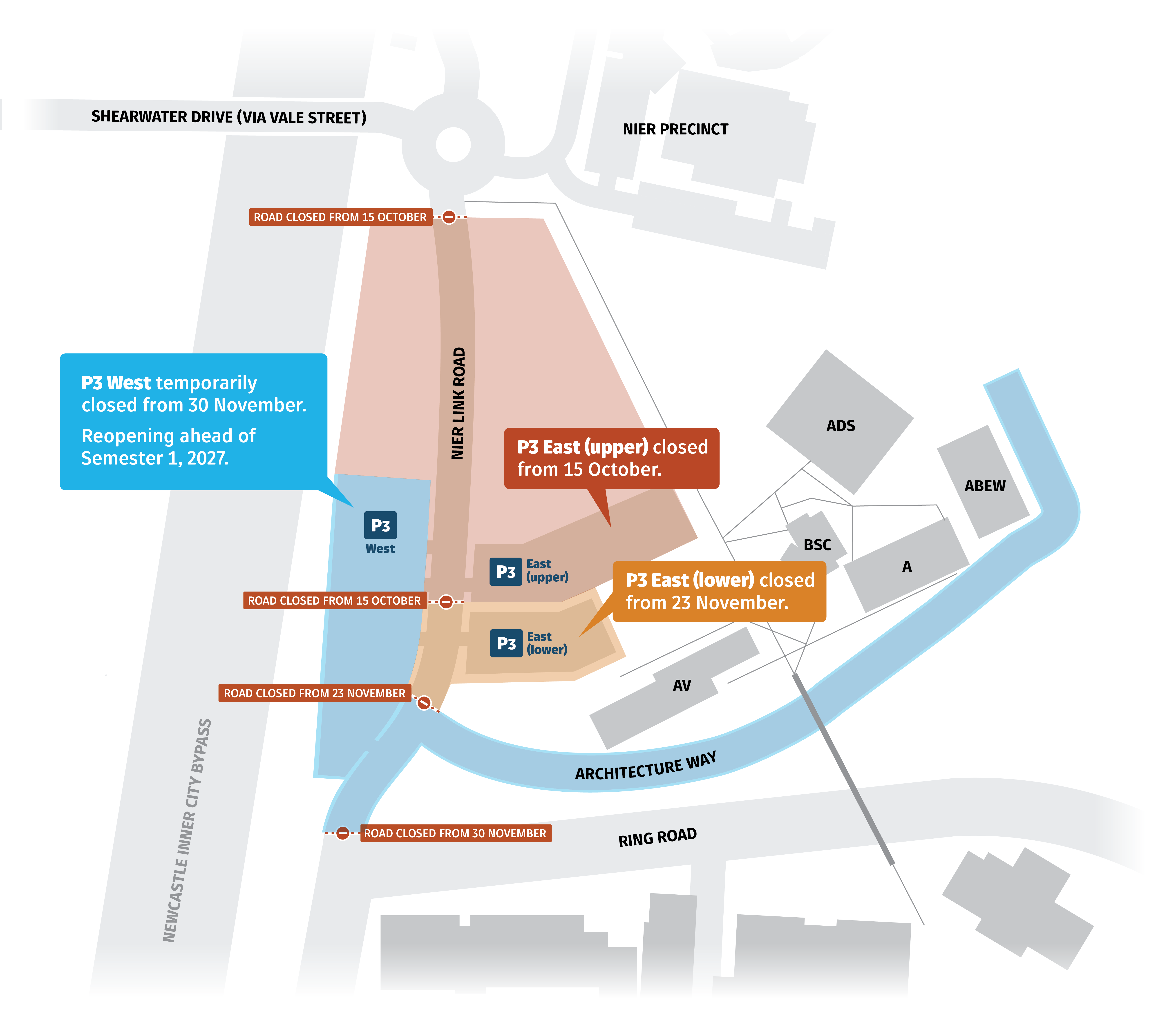
To support infrastructure works for the Next Generation Resources Park, a series of temporary road closures and parking changes will be in place within the NIER precinct from October 2026 to January 2027.
These works have been carefully staged to minimise disruption to students, staff and campus operations, with the most disruptive activities scheduled after the exam period and during the Christmas shutdown.
Key changes include:
- Incremental closures along NIER Link Road from 15 October 2026. Re-opening ahead of Semester 1, 2027.
- P3 East (upper) closed from 15 October.
- P3 East (lower) closed from 23 November.
- P3 West closed from 30 November. Reopening ahead of Semester 1, 2027.
On-ground signage is informing users of the changes.
There is no change to pedestrian access to the Architecture Precinct.
Vehicle access to the NIER precinct will be exclusively via the Vale Street and Shearwater Drive entrance.
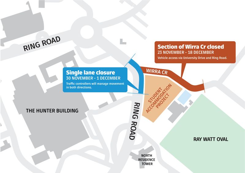
Construction works associated with the new Student Accommodation Project will temporarily affect traffic, parking access and shuttle services around Wirra Crescent and Ring Road.
Wirra Crescent will be closed from 23 November to 18 December, with alternative vehicle access available via University Drive and Ring Road.
A single-lane closure will also be in place on Ring Road from 30 November to 1 December. Traffic controllers will manage movements through the area and maintain access in both directions.
Additional traffic and wayfinding signs will be installed near Car Park 14 and along University Drive. Please follow all temporary signs and directions from traffic management staff to help keep motorists, pedestrians and construction workers safe.
Pedestrian access map
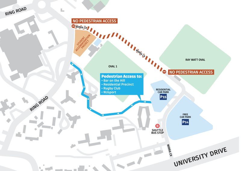
Higher traffic volumes are expected during the Student Living move-out on 28 and 29 November. Students requiring access to West Tower should approach via Ring Road, allow additional travel time and take extra care around pedestrians and vehicles loading belongings.
University shuttle services may experience delays at times due to changed traffic conditions. Please allow additional time for your journey and track your shuttle in the myUni app for real-time service information.
Some construction noise is also expected, including periods of saw-cutting lasting approximately two to three hours. The project team is mindful of the examination period and will manage the works as carefully as possible to minimise disruption.
Swimming carnivals are proposed for 30 November, 3 December and 7 December, subject to confirmation. Attendees are encouraged to park in Car Park 7, near Bar on the Hill, and follow event and traffic signage.
We appreciate that these temporary changes may cause inconvenience and thank the University community for its patience and cooperation. Please plan ahead, allow additional travel time and take extra care when moving through the area.
Wirra Crescent traffic impact map
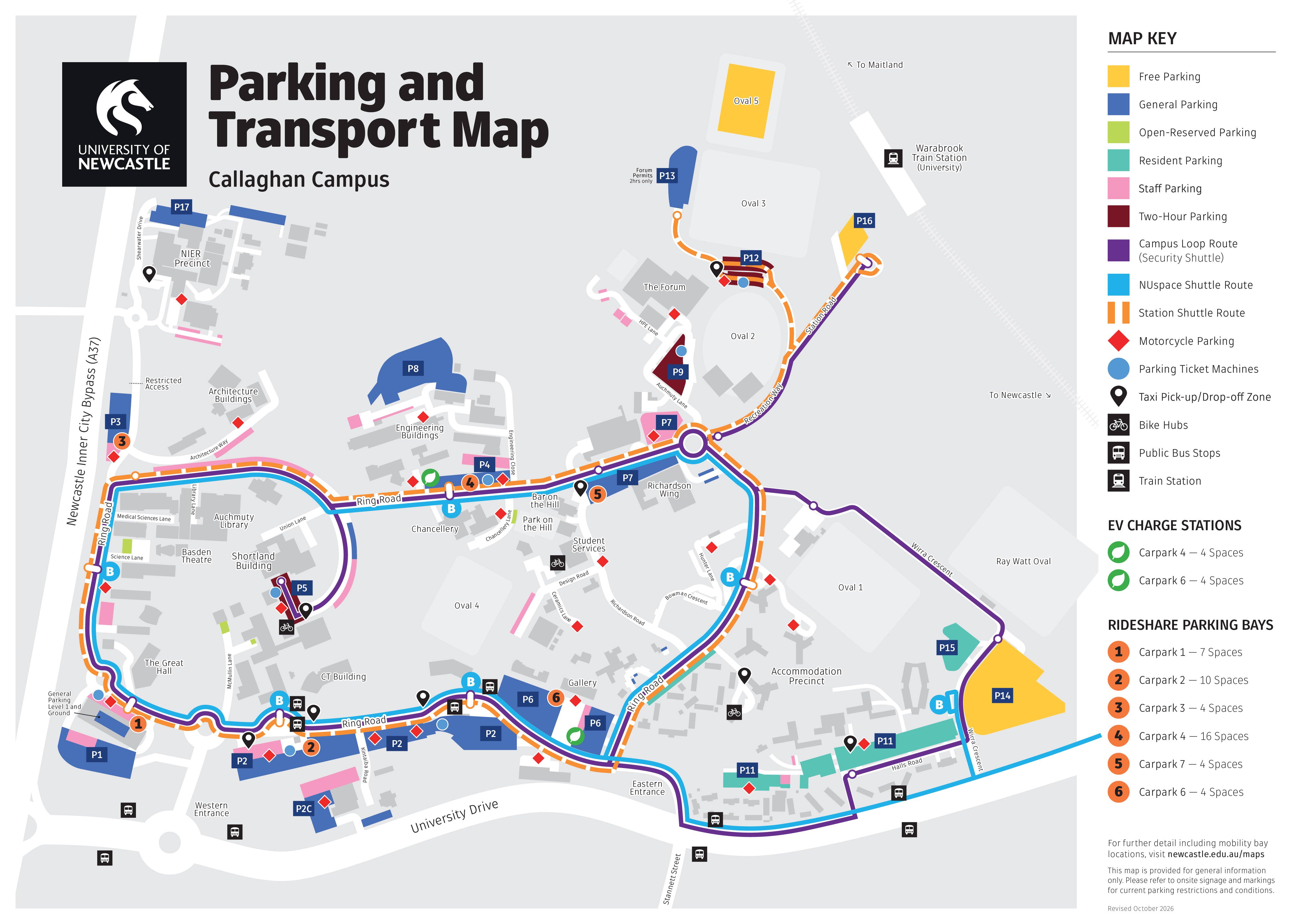
Download the Parking and Transport Map or visit our transport page.
.
The new Callaghan Student Accommodation project will temporarily reduce parking capacity during construction, but will ultimately increase overall, including adding 2 accessibility parks and 3 EV charging bays.
These disruptions are expected to take place from 7 October 2026.
Specifically, parking spaces in Car park 10 (Rugby Club car park) and ar park 7C (opposite North Tower between Ring Road and the Hunter Building) will be temporarily removed during construction.
I live on campus. Where can I park?
Students living on campus who currently use a general parking permit to park in these locations have a few options available:
- Switch to a residential permit by cancelling your general permit. A residential permit provides access to designated residential parking areas: CP11 and CP15.
- Use free parking by cancelling your general parking permit and park in P14 and Oval 5.
- Keep your general parking permit and continue parking in other available campus car parks, such as P6.
I am staff or a student. Where can I park?
- Students and staff can access general parking. The closest car parks are CP7 (near Bar on the Hill), CP6 (Gallery), or Forum car parks 9, 12 and 13.
- Free parking is also available at CP14, CP16 and Oval 5. See map below.
Download the Parking and Transport Map or visit our transport page.
The University is expanding the route and timetable of the Station shuttle – it now starts at 7am and goes around the Ring Road including CP13.
All University shuttles can now be tracked through the myUni app, with timetables and current alerts available to help plan your journey.
Download the Parking and Transport Map or visit our transport page.
The University has expanded free overflow parking on Oval 5 (near CP13). This large, grassed parking area is accessible through car park 13 and will be upgraded in 2027 to an increased capacity of 195 spaces, from 100 spaces currently. From the NUsport roundabout take the road that leads to Warabrook station, veer left through CP12 and CP13. This area is now serviced by the Station shuttle.
Download the Parking and Transport Map or visit our transport page.
The University of Newcastle acknowledges the traditional custodians of the lands within our footprint areas: Awabakal, Darkinjung, Biripai, Worimi, Wonnarua, and Eora Nations. We also pay respect to the wisdom of our Elders past and present.