Australia's frontier violence exposed
University researchers created a world-first digital map to expose massacres on Australia’s Colonial Frontier.
Australia’s colonial history has, and continues to be, highly contested. Were conflicts between British settlers and Indigenous Australians relatively minor and isolated – or were they deliberate, widespread and overtly violent?
Researchers at the University of Newcastle discovered new information that’s changing our collective understanding of this difficult time in Australia’s history.
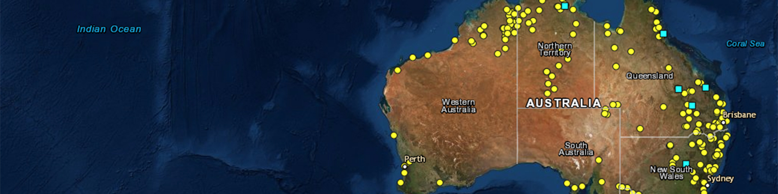
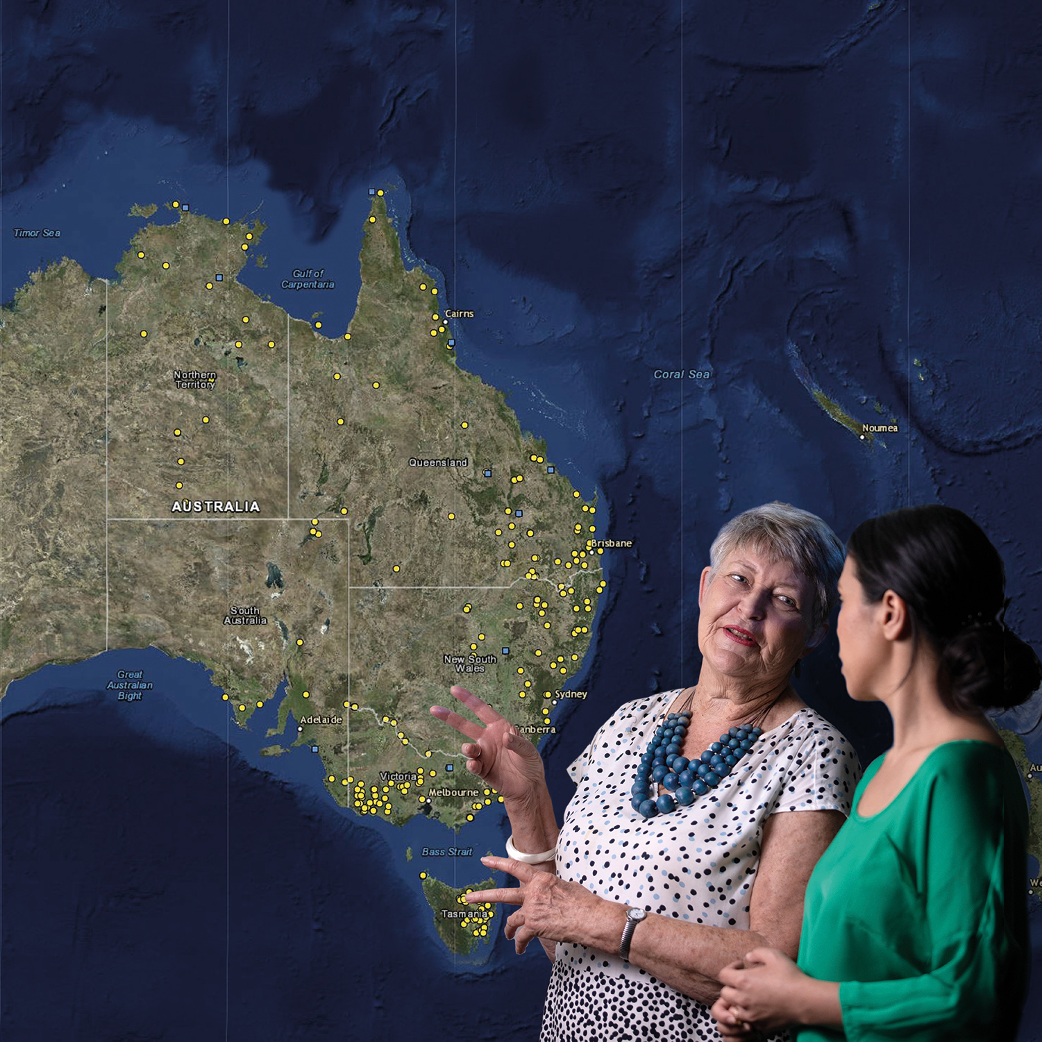
Following years of painstaking investigation, they created a world-first interactive digital map that documents the massacres that occurred on Australia’s colonial frontier and the impact those events have had, particularly on Aboriginal and Torres Strait Islander peoples.
The research
Developed by researchers from the university’s Centre for 21st Century Humanities, the Colonial Frontier Massacres Map documents the locations, dates and details of individual massacres, along with corroborating evidence for each event.
The team estimates that more than 10,000 Aboriginal and Torres Strait Islander lives were lost in over 400 massacres, in contrast with 168 non-Aboriginal people.
The research team used a wide range of sources to verify the massacres, including settlers’ diaries, explorers’ journals, newspaper reports, survivor testimonies, Parliamentary papers, court reports and government archives.
With a clear definition of a ‘frontier massacre’ – the indiscriminate killing of six or more undefended people in one operation – the team used mapping software to record the geographical coordinates and topographical features of each site. They then cross-checked that information with visual and written sources.
The collective details were shared with a team of system architects, digital cartographers and engineering students from the University of Newcastle who created the Colonial Frontier Massacres Map.
The research group discovered that most massacres occurred on private property with no public access – such as the site of the Myall Creek massacre in 1838 – or at local waterways.
Their investigations also supported the theory that many of the massacres were surprise attacks on Aboriginal camps at rivers, creeks and waterholes. Some took place during droughts, when access to water and livestock was hotly contested.
A true community resource
One of the unique features of the map and its corresponding website is that the public can get involved in the history-making process.
Following the map’s initial launch in 2017, more than 700 people (including descendants of victims, survivors or perpetrators) contacted the research team with new information about massacre events.
The late Emeritus Professor Lyndall Ryan (who led this important research) believed the map gave a voice to people in Australia who want the stories of these massacres told.
In 2019, the research team partnered with The Guardian newspaper on a four-part series called ‘The Killing Times’.
Using data from the original massacres map and the same stringent research methods deployed by University of Newcastle researchers, ‘The Killing Times’ produced a number of stories that may have been familiar to academics, historians and Indigenous people but were largely unknown within the wider Australian and international communities.
Evidence of impact
Not only is the massacres map reframing our understanding of what really happened in colonial Australia – it’s also leading to a more informed discourse about our country’s true history.
The map has been viewed nearly one million times since its initial release in 2017. It’s also received world-wide media coverage, with news stories in Reuters World News, CNN, the Smithsonian, the New Yorker, Japan’s Kyoto News, Voice of America, the New Zealand Herald, the Daily Mail, and multiple Australian news outlets. It’s estimated the partnership with The Guardian Australia alone has generated more than 25 million media impressions.
That partnership won the 2019 NSW Premier’s History Prize (Digital History category). In awarding this honour, the judges noted that the collaboration made a profoundly important contribution to history and public debate:
“By pairing contemporary sources with cutting-edge technology, the creators of ‘The Killing Times’ have produced a resource that challenges, provokes and demands more from Australians.”
‘The Killing Times’ received a 2019 Walkley Award for coverage of Indigenous affairs, with the judging panel noting the project was:
“A timely work of national significance that will have lasting impact…Devastating but important.”
Project milestones
- July 2017: Stage 1 of the massacres map goes live, with 172 sites along eastern Australia.
- July 2018: Stage 2 goes live, with over 260 sites featured – including some in South Australia and the Northern Territory.
- November 2019: Stage 3 goes live and for the first time documents massacre sites in Western Australia. The total number of confirmed massacre sites stands at 311 and counting.
- March 2022: Additional information about the scale of frontier massacres is released in Stage 4 of the project, in partnership with The Guardian Australia.
More information:
Emeritus Professor Lyndall Ryan passed away in April 2024.
While this particular research effort has concluded, Professor Ryan's work and legacy live on in the Colonial Frontier Massacres Map.
Considered a significant step in the recognition of the periods of violence in Australia’s history, the map is a contact point for the public to contribute historical information they may have about massacres.
Emeritus Professor Lyndall Ryan
The map gives a voice to people in Australia who want the stories of these massacres told.
Aligned with the United Nations Sustainable Development Goals
Read more research impact case studies
The University of Newcastle acknowledges the traditional custodians of the lands within our footprint areas: Awabakal, Darkinjung, Biripai, Worimi, Wonnarua, and Eora Nations. We also pay respect to the wisdom of our Elders past and present.