Projects
Below is a list of our current or recent projects.
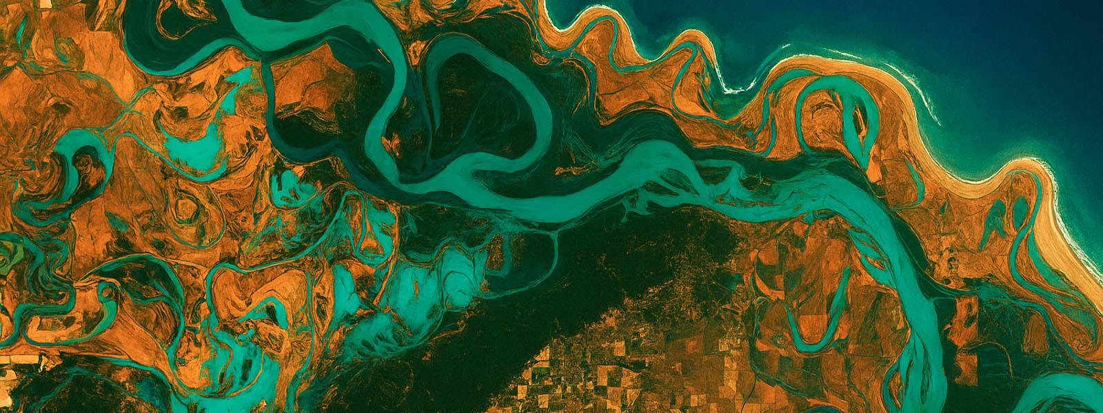
Where Land Meets Sea: Groundwater Connections in Coastal Ecosystems
Coastal wetlands are critical transition zones where groundwater and ocean processes interact to shape salinity regimes, water levels, and ecological function.
These systems are highly sensitive to climate variability and human interventions, such as artificial lagoon breaching and water-level regulation, which increasingly disrupt the balance between freshwater and saltwater inputs.
This project investigates the hydrogeological mechanisms that control freshwater–saltwater exchange and groundwater–surface water connectivity in coastal wetland environments. Using an integrated, multidisciplinary approach - combining hydrological monitoring, geophysical imaging, and salinity profiling. The study characterises how lateral and vertical flow pathways govern the movement of water and solutes across the land–sea interface.
Results show that groundwater discharge can provide a critical buffering role, sustaining freshwater conditions and supporting biodiversity, but this natural regulation is often constrained by anthropogenic modification. The ecological consequences of these interactions are evident in the vulnerability of freshwater-dependent species, such as the endangered Green and Golden Bell Frog, which rely on narrow hydrological and salinity ranges. By advancing understanding of coastal groundwater–ocean interactions, this project contributes to the development of adaptive management strategies that integrate groundwater processes into wetland and coastal ecosystem management under future climate and sea-level change.
Where Land Meets Sea: Groundwater Connections in Coastal Ecosystems
Coastal wetlands are critical transition zones where groundwater and ocean processes interact to shape salinity regimes, water levels, and ecological function. These systems are highly sensitive to climate variability and human interventions, such as artificial lagoon breaching and water-level regulation, which increasingly disrupt the balance between freshwater and saltwater inputs. This project investigates the hydrogeological mechanisms that control freshwater–saltwater exchange and groundwater–surface water connectivity in coastal wetland environments.
Using an integrated, multidisciplinary approach - combining hydrological monitoring, geophysical imaging, and salinity profiling - the study characterises how lateral and vertical flow pathways govern the movement of water and solutes across the land–sea interface. Results show that groundwater discharge can provide a critical buffering role, sustaining freshwater conditions and supporting biodiversity, but this natural regulation is often constrained by anthropogenic modification.
The ecological consequences of these interactions are evident in the vulnerability of freshwater-dependent species, such as the endangered Green and Golden Bell Frog, which rely on narrow hydrological and salinity ranges.
By advancing understanding of coastal groundwater–ocean interactions, this project contributes to the development of adaptive management strategies that integrate groundwater processes into wetland and coastal ecosystem management under future climate and sea-level change.
Process-based modelling of coastal wetland evolution
Coastal wetlands are among the most productive ecosystems in the world, providing habitat for fish and birds and supporting the productivity of adjacent coastal waters by exporting nutrients. They are particularly vulnerable to sea-level rise due to their location in low lying areas, as shown by a number of studies that have predicted the submergence of 20–78% of worldwide coastal wetland extent by the end of the century.
Wetlands accrete due to their capacity to trap sediments and to incorporate dead leaves, branches, stems and roots into the soil, and they migrate driven by the preferred inundation conditions in terms of salinity and oxygen availability. Accretion and migration strongly interact, and they both depend on water flow and sediment distribution within the wetland, so wetlands under the same external flow and sediment forcing but with different configurations will respond differently to sea level rise (SLR). Analyses of wetland response to SLR that do not incorporate realistic consideration of flow and sediment distribution are likely to result in poor estimates of wetland resilience.
This project investigates how accretion and migration processes affect wetland response to SLR using a computational framework that includes all relevant hydrodynamic and sediment transport mechanisms that affect vegetation and landscape dynamics, and it is efficient enough computationally to allow the simulation of long time periods.
Marine microbes
This research focusses on understanding the ocean’s tiniest living inhabitants – microorganisms. They underpin the biogeochemical cycles of this planet and facilitate the health and wellbeing of the larger organisms they inhabit. The underlying aim of this project is to deliver globally relevant information regarding the impacts of climate change to marine ecosystems, with particular emphasis on how microbial communities will respond to future warming and other anthropogenic impacts such as metal contamination, ocean acidification and eutrophication.
Enhancing Nature’s Unique Areas: Catchment Audits to Inform Environmental Management
In the Pacific region, the impact of catchment activities is a major focus for attention by governments and the community. Agriculture, urbanisation, industrial development, tourism and recreation, are known to degrade natural resources landscapes.
A "catchment to coast" concept identifies the linkages between landscape, catchment, waterway (stream, creek or river), estuary and coastal condition and provides the rationale behind the process-based integration of natural resource data. The purpose of a Catchment Audit (CA) is to identify key landscape and landuse features that have potential to affect waterways, including downstream cumulative effects where the waterway flows into the nearshore zone.
This project will use a range of biophysical indicators to undertake a catchment audit, identify areas that could potentially be exhibiting environmental issues and then informing the sampling design for monitoring. Focussing on four (4) priority catchments on the island of Rartonga (Avana, Avatui, Takuvaine and Turangi), this project will work with government (National Environment Service) and community (Muri Environment Care) to develop community-led catchment management plans to safeguard globally significant biodiversity and core ecosystem services.
Hidden Histories of NSW’s Iconic Trees: Advancing Water Management and Climate Research
Floodplain eucalypts represent a previously untapped archive for reconstructing pre-instrumental hydrological variability in eastern Australia. These iconic trees, including Eucalyptus coolabah and Eucalyptus camaldulensis from the Gwydir Wetlands, hold the potential to extend records of floods and droughts well beyond the short span of instrumental monitoring. In this study, we combine radiocarbon dating with advanced image enhancement techniques to identify annual growth markers preserved in cross-sections of long-lived floodplain eucalypts.
Preliminary analyses suggest that these growth features vary systematically with climate extremes, including periods of extended drought and large flood events. By linking growth characteristics to hydroclimate variability, our findings provide new insights into the long-term water history of the Murray–Darling Basin.
This research not only establishes a novel palaeohydrological proxy for Australia but also offers critical information for water resource management, ecological conservation, and planning for climate extremes in vulnerable floodplain ecosystems.
The environmental antimicrobial resistome, its persistence and pathways to resilience
Antimicrobial resistance (AMR) is a natural microbial response to microbial competition. However, due to the overuse of antibiotics, it is now a critical global health and environmental challenge that is projected to cause 10 million deaths annually by 2050.
The environmental factors underpinning the maintenance and dissemination of resistance genes in aquatic systems is poorly understood. Further, the impact of pollutants such as heavy metals in promoting the dissemination of AMR in wastewater, freshwater and estuarine systems is underexplored, although strong associations have been observed.
We investigate how environmental stressors influence the persistence and transfer of AMR genes in microbial communities using advanced ‘omic based technologies and in vitro laboratory models. The findings will support development of diagnostic tests for environmental AMR monitoring and inform bioremediation strategies to mitigate the spread of AMR in aquatic systems.
Cyanobacterial blooms, cyanotoxins and the role of antimicrobial resistance
Cyanobacterial blooms are increasing in frequency and severity due to climate change and nutrient enrichment. Blooms often release cyanotoxins that disrupt aquatic ecosystems and pose significant risks to human and animal health. Cyanobacteria harbour antimicrobial resistance genes (AMR), raising concerns on the potential for AMR dissemination during a bloom event.
Further, the production of cyanotoxins during a bloom, is known to increase rates of horizontal gene transfer, a major mechanism of AMR dissemination.
Our work explores the role of cyanobacterial blooms in shaping the environmental resistome and how cyanotoxins influence microbial community structure through toxin-mediated stress. It provides critical knowledge on the consequences of cyanobacterial bloom events, informing water management strategies.
Passive Subsurface Characterisation: Using standard groundwater monitoring datasets to estimate subsurface hydro-geomechanical properties
Traditional hydraulic testing is costly and infrastructure-dependent, limiting its use. Passive Subsurface Characterisation (PSC) instead analyses groundwater responses to natural forces - such as Earth tides and atmospheric pressure - to infer confinement and estimate hydro-geomechanical properties in situ. PSC requires only standard groundwater and barometric pressure records, along with theoretical Earth tides, which are easily calculated. PSC provides a cost-effective way to estimate parameters such as hydraulic conductivity, specific storage, porosity, and elastic moduli.
Applications from field sites worldwide demonstrate that PSC can recover the full poroelastic parameter space. As an underutilised technique, PSC has strong potential to enhance groundwater monitoring practices and unlock new insights from standard datasets.
Episodic Groundwater Recharge in Drylands: Modelling Variably Saturated Infiltration and Groundwater Replenishment
Groundwater recharge in arid and semi-arid environments is highly episodic, controlled by short-lived but intense rainfall events that must exceed soil moisture deficits, infiltration thresholds, and evaporative losses. Because diffuse infiltration across dryland landscapes is limited, recharge often occurs through focused zones such as ephemeral streambeds, floodplains, and depressions, where transient surface flow promotes deep percolation. However, the spatial and temporal variability of these processes makes quantifying recharge extremely challenging.
To address this, numerical simulations of variably saturated flow are employed to model infiltration dynamics under realistic boundary conditions. These simulations - using Richards’ equation and parameterisations of soil hydraulic properties - allow investigation of how rainfall intensity, soil texture, and antecedent moisture influence infiltration depth, percolation rates, and potential recharge.
By integrating field monitoring with such models, the project quantifies episodic recharge fluxes and identifies thresholds that govern water movement through the unsaturated zone. Ultimately, this approach advances understanding of how dryland aquifers are replenished, providing a foundation for sustainable groundwater management under increasing climatic extremes.
Enhancing water security in regional communities: an evaluation of more economically accessible treatment technologies for wastewater recycling
Water security is a critical concern for regional communities throughout Australia. To enhance drought resilience regional centres are exploring various supplementary water supply options including wastewater recycling.
For recycling wastewater for potable and other higher risk re-uses, reverse osmosis is considered an optimum treatment process. While the reverse osmosis process provides a high-quality product, the technical complexity and high capital and operating costs, are beyond the means of most regional centres.
Of particular concern in relation to recycled water quality are risks posed by contaminants of emerging concern (CEC), including endocrine disrupting compounds (EDC), potentially present in the wastewater stream.
This project will comprise assessment of the ability of alternate treatment processes to remove critical contaminant groups (including CEC/EDC) and hence the risk associated with various end-use applications.
The objective is to evaluate the capacity of more economically and environmentally sustainable treatment technologies to deliver recycled water suitable for a broad range of applications, potentially enhancing the portfolio of supply options for water sustainability in regional centres.
Enhancing Heatwave Resilience in Vulnerable Communities: A Comprehensive Risk Assessment and Preparedness Initiative for Local Government Areas (LGAs)
Heatwaves are Australia’s deadliest natural hazard, and their frequency, duration, and intensity are increasing under climate change. The Heatwave Hub, funded by the Disaster Ready Fund aims to improve understanding of where and why communities are most at risk from extreme heat and to support targeted adaptation and resilience planning across New South Wales (NSW).
Using advanced geospatial analysis and modeling, the project will identify vulnerable populations, assess current and future heat risks, and pinpoint best practices for heatwave adaptation. Collaboration with Local Government Areas (LGAs) ensures that councils can integrate heatwave resilience into urban planning and service delivery.
Through interviews, focus groups, and co-design workshops, stakeholders will collaboratively identify gaps, share experiences, and develop locally relevant strategies. By combining data-driven insights with participatory approaches, the Heatwave Hub empowers communities, strengthens planning and service delivery, and helps reduce the health and social impacts of increasingly frequent and intense heatwaves.
Past cyclone fingerprints in tree rings: Using palaeotempestology for tropical cyclone resilience of Northeast Australia
This project investigates whether tropical cyclones leave a measurable imprint in the growth rings and isotopic composition of Callitris intratropica, a long-lived conifer native to northern Australia. By analysing variations in oxygen and carbon isotopes (δ¹⁸O, δ¹³C) and annual growth patterns, the research aims to determine how cyclones such as Tropical Cyclone Olga (2010) are recorded in the tree’s structure.
Linking these signals to historical cyclone and rainfall data will allow the research team to extend the record of tropical cyclone activity beyond the instrumental era, providing new insights into the long-term behaviour of extreme weather in northern Australia and how it may shift under future climate change.
Fingerprinting the Eemian as an Analogue for Future Climate Change
This Australian Research Council (ARC)-funded project investigates how rainfall patterns and the South Pacific Convergence Zone (SPCZ) responded to natural warming during the last interglacial period - the Eemian (~127,000 years ago) - to better understand how the climate system may behave under future global warming.
Using speleothems (cave deposits) from the Cook Islands, Makatea, and eastern Australia, the research reconstructs past tropical rainfall and ocean–atmosphere interactions during a period when global temperatures were 1–2°C warmer than today.
By combining high-resolution geochemical analyses with state-of-the-art climate model simulations, the team will evaluate how well current models capture SPCZ variability under warm climate conditions. The findings will improve confidence in projections of future hydroclimate change and extreme rainfall risk across the South Pacific.
The project is led by researchers at the University of Newcastle, in collaboration with national and international experts in geochemistry, climate modelling, and Pacific climate dynamics.
Moving Toward Data-Driven Images Using Ground-Penetrating Radar to Characterize Tree Root Networks
Trees are among nature’s tallest free-standing structures, found on every continent except Antarctica. They can live for centuries; species such as the bristlecone pine (Pinus longaeva) and baobab (Adansonia digitata) are known to reach thousands of years of age.
From an engineering perspective, their design seems counterintuitive: a massive top-heavy canopy supported by a single slender trunk. It is natural to wonder - how does the root system stabilize such a structure? How deep do roots extend? How far have they spread? Where does the tree source water?
These questions are critical to understand why and how Australia’s floodplain eucalypts have become uniquely adapted to withstand both floods and droughts. Yet, these questions remain poorly understood. This research focuses on utilising near-surface geophysics - specifically ground penetrating radar, to characterise the root networks of trees.
Preliminary work, collected around a large (DBH ~3 m) River Red gum on the edge of the Murray-Darling in SA show that we can characterize the intricate details of roots and that they can extend as far away as 15 m from the trunk. Roots remain challenging to quantify because they are small, but complex and dendritic structures that are embedded into tens to hundreds of cubic meters of soil.
We are addressing this challenge, which will provide a new subsurface perspective on Australia’s most iconic trees to help us understand ecosystem resilience as we continue to extract groundwater extraction, regulate our rivers and as climate change impact water availability.
The University of Newcastle acknowledges the traditional custodians of the lands within our footprint areas: Awabakal, Darkinjung, Biripai, Worimi, Wonnarua, and Eora Nations. We also pay respect to the wisdom of our Elders past and present.