
Rockfall research that's saving lives
Rockfall researchers at the University of Newcastle have pioneered discoveries that are saving lives on our roads, at our mine sites and in at-risk communities.
The natural and constructed rock slopes along our highways, railways, mountain communities and coastal towns can pose significant risks to lives and infrastructure if not managed well.
Yet much of the world’s research about rockfalls comes from the mountainous areas of Europe, North America and Japan, which are quite different from the unique landscapes of Australia.
Experts at the Centre for Geotechnical Science and Engineering are changing the research landscape by delivering cutting-edge innovations that are improving the safety of Australia’s roads, industrial sites, neighbourhoods and recreational areas.
Rockfall innovations
The University research team has established multiple indoor and outdoor testing facilities to conduct full-scale experiments that investigate rockfall phenomena. Learnings are used to inform the design of cost-effective protection and mitigation systems specific to Australian conditions.
One of the facilities is a fragmentation cell that measures impact forces of rock fragments and uses synchronised high-speed cameras to track their trajectory. Located on the University’s Callaghan campus, the fragmentation cell is the only facility of its kind in the world. Work carried out there led to an innovative prediction model for rock block breakage upon impact. It also sparked an ongoing collaboration with the Canadian-based firm Rocscience – one of the largest geotechnical software companies in the world.
The research team is using artificial intelligence and machine learning to predict rockfall motions and determine hazards along recreational areas that line coastal cliffs and in mining locations. This work will give governments and industry important insights that support future use planning.
Various mine sites are using a low-cost photogrammetric monitoring system developed by the research team to identify sources of potential rockfalls on rock surfaces, as well as the potential quantity of detached volumes. The team also developed the VoxFall plugin – a free and open-source framework that helps detect changes and characterises the distribution, volume and location of detached rocks from a cliff.
Researchers at the Centre for Geotechnical Science and Engineering have also:
- used numerical modelling to assess protective measures in Australian surface mining operations, which enabled accurate predictions of rockfall trajectories and velocities from highwalls with drapery
- developed a novel rockfall hazard methodology called ERHA (Evolving Rockfall Hazard Assessment), which comes with a web application to improve safety aperators quickly identify the most hazardous sections of a highwall
- definitively demonstrated the influence of geology on block size and shape in the Australian context, which is key to understanding the potential trajectory of rock should it come loose. This knowledge underpins the ability to use remote sensor techniques to map the geological structures visible on rock faces, so engineers can more accurately characterise the distribution, volume and location of potentially unstable rock areas.
Research impact
- The Centre for Geotechnical Science and Engineering has been collaborating with the Newcastle City Council to identify potential instabilities in coastal cliffs due to intense weather patterns. Following a massive deluge of rain over several days in May 2025, University researchers identified instability in the cliff line along South Newcastle Beach – one of the most widely used coastal stretches in the city. They're now working with the council on the monitoring and remediation of this popular stretch of coastline. The team's data and insights into cliff formations and evolution is informing Council decisions relating to safety and economic viability more broadly.
- Transport for NSW adopted improved rockfall barriers on its road network based on the team’s research.
- Major players in the mining sector – including Yancoal, Anglo American, Thiess, Glencore and BHP Mitsubishi Alliance – use the ERHA web app to assess rockfall hazards.
- Australia’s mining and civil sectors use the team’s evidence-based methods to predict the residual hazard of rockfall drapery systems, which helps them define exclusion zones and mitigate site risks. They’re also designing better protective measures thanks to the team’s invention of a novel, cost-effective method to quantify the amount of energy it would take to cause a failure in rockfall meshes.
- The research team’s proven track record has earned them a prestigious Australian Research Council Discovery Project grant of more than $800,000. Awarded in October 2025, the project will develop new methods to monitor and predict coastal cliff erosion under changing climate conditions, to help reduce risks in coastal communities.
Supporting safety near cultural heritage sites
Originally developed for open-pit coal mines, the Evolving Rockfall Hazard Assessment methodology has a range of applications, including assessing hazards of cultural heritage sites.
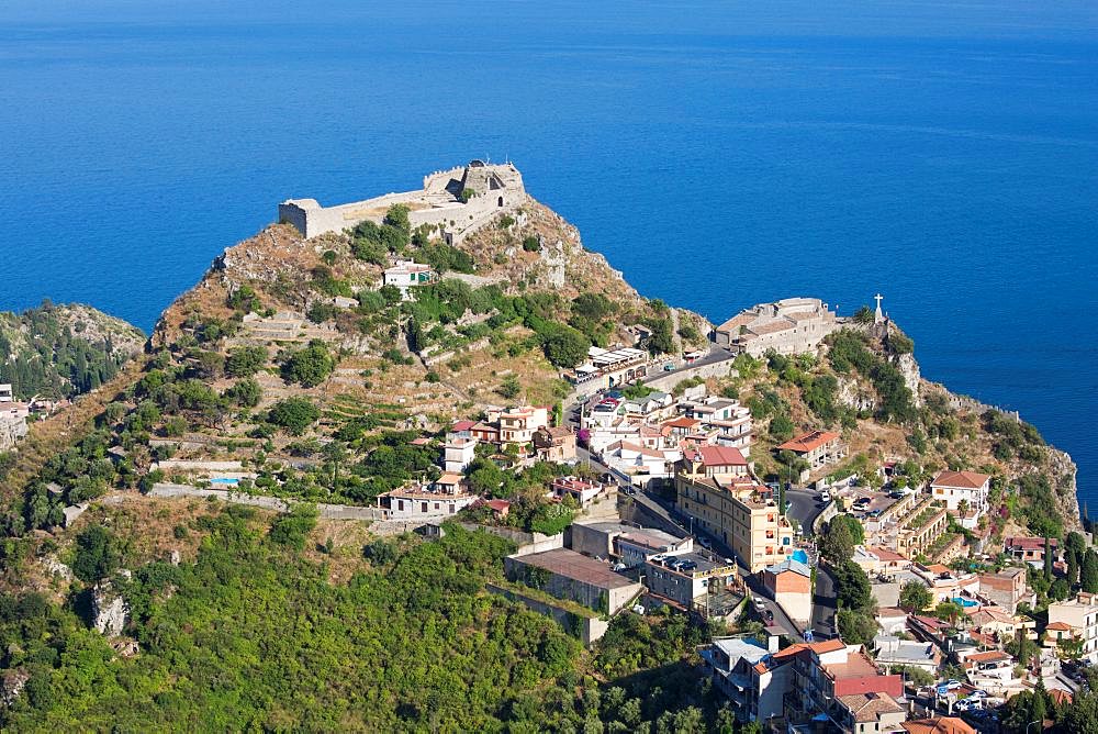
Italian academics used ERHA to assess unstable rock cliffs in Taornima, Italy – home to the Saracen Castle. Built between the 11th and 12th centuries, the castle sits nearly 400 metres above the city. ERHA helped identify high hazard zones at the foot of the cliff and along tourist paths and roads. Armed with this information, local authorities could better plan short and long-term hazard reduction strategies for this culturally significant site.
Professor Anna Giacomini
The Centre for Geotechnical Science and Engineering has unlocked a new era in rockfall understanding and analysis that is having a positive impact in Australia and around the world.
More information
Professor Anna Giacomini
Director of the Centre for Geotechnical Science and Engineering
T: +61 2 4921 6254
E: Anna.Giacomini@newcastle.edu.au
Last updated November 2025
Aligned with the United Nations Sustainable Development Goals

Read more research impact case studies
The University of Newcastle acknowledges the traditional custodians of the lands within our footprint areas: Awabakal, Darkinjung, Biripai, Worimi, Wonnarua, and Eora Nations. We also pay respect to the wisdom of our Elders past and present.